What if you are shopping for homes and would like to know how the commute would be every weekday morning at 8:00am?
Back in the time of the big fat telephone directories, there used to be a saying: “let your fingers do the walking”.

Let your fingers do the walking
For some of us who are too young to remember when there was no Internet (wink…), this saying came from an ad promoting the Yellow Pages.
And can this great idea of using your fingers to do the walking help with estimating your future commute?
The idea of using your fingers was to flip through the Yellow Pages phone directories to find products and services by calling the businesses that appeared in the directory, without having to walk or drive for miles to try to physically find what you needed.
Nowadays, we use the internet for pretty much everything
Aside from finding products and services, one of the things that we use the Internet the most is for getting directions.
Most people now turn to Google Maps, or some other online map service, to find out how to get from one place to another.
And now most online maps have evolved to show traffic conditions in real time. (A very convenient feature when you are requesting directions!)
In addition to getting directions, we also use online services to shop for homes.
We also use the internet to shop for homes
And once they have a list of homes they like, they want to estimate how long will it take them to get to work.
To figure out their commuting time, the most obvious thing to do for many people is to get up earlier than normal on several weekday mornings (oof…), go to each potentially new home and start their commute from there to experience it first-hand.
Or, you could estimate your commute using Google Maps
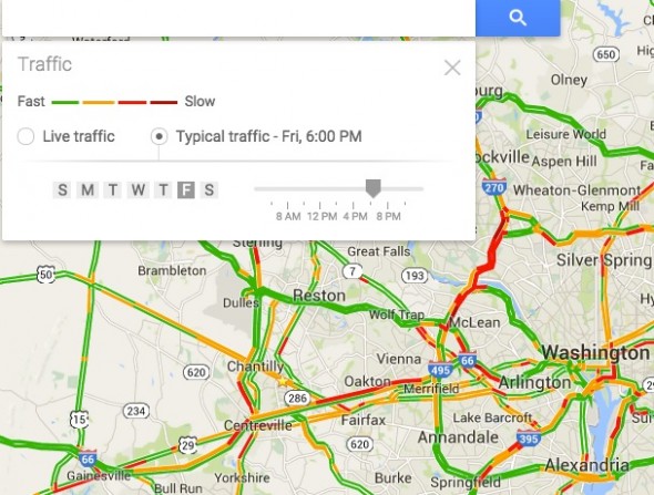
Did you know that on Google Maps (desktop only), there is a historic traffic option where you can select the day and time and it will give you “typical” (i.e. average) traffic conditions?

Typical Traffic conditions on Friday evening
This is how you get to see Typical Traffic, by clicking on the Traffic link below the search box on google.com/maps:

Click on Traffic to see real time or Typical traffic
Isn’t it great to “Let your fingers do the walking”?
So now you know: the next time when you are trying to get an idea of how long it will take you to get to work if you were to buy that amazing, gorgeous home in your favorite school boundary, “let your fingers do the walking”.
Log into Google Maps on your desktop to check out the typical traffic conditions.
Still, it would be wise to drive your commute at least once
We still suggest you drive the commute at least once to really know for sure what it might be like, but it will hopefully only be once, after you are comfortable with the time estimate that you found online.
And, did you know that you can find homes for sale by school boundary on this site?
If you would like to find homes by school, log into our Fairfax County Map.
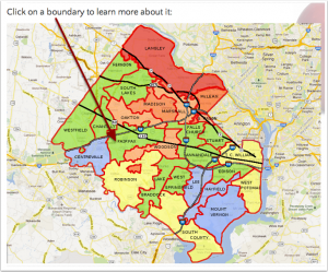
Once you’re on the Fairfax County Map, select the high school boundary of your choice and click to find homes for sale:
Click for the Fairfax County Map of High School Boundaries
Access the Fairfax County Map of School Boundaries to see the location of each of the most UP-TO-DATE boundaries within Fairfax County and to choose your ideal boundary.
When you access the Fairfax County Map of School Boundaries, you will find:
- Homes for Sale in our interactive map
- UP-TO-DATE High School boundaries
- School scores for elementary, middle and high schools in each boundary
- Photos and videos
- Highlights of the area covered by each boundary
- Statistics about housing
- Transportation options
If you haven’t subscribed yet, why wait?
Downloading The No-Tears Guide to Moving to Fairfax, VA is free, and you’ll get access to our unique home-search (by school boundary).
Plus, you get the Fairfax County Real Estate Affordability Map, AND access to detailed information about each Fairfax County School boundary.
* Photo by David Prasad on Flickr, Map images from Google®


 Everybody is welcome to find a home by school boundary. A school boundary
is simply a geographical area, just like a zip code or a postal city.
 Does anything on this website bug you? Nothing is too small or too big. If there is something we can fix, we'd love to know.

