Jenny is a successful attorney who works in Downtown Washington, D.C. Her son, Max, is getting ready to enter 1st grade and she would like him to be in the best school possible.
Jenny also wants to have the shortest commute time since she wants to help Max with his homework every evening.
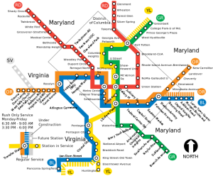
Map of the Washington D.C. METRO rail
Max and Jenny have decided to live near the METRO, so that she can ride it every day to work.
What is the METRO?
The METRO is Washington D.C.’s rapid transit system, which connects Washington D.C. with parts of its suburbs. In Virginia, there are four lines that service Fairfax County.
The METRO’s existing lines in Fairfax County are:
- Blue
- Yellow
- Orange
- Silver (slated to open at the end of 2013)
With these four METRO lines as options for commuting into DC, Jenny thought that there had to be several home options that met her criteria of being near a METRO station, and belonged to a good school boundary. So, she dug in to find the right place to live.
Her first step was to identify the school boundaries accessible to the METRO:
School boundaries accessible to the DC METRO
The school boundaries most accessible to the Orange and Silver lines of the METRO are:
- McLean
- Marshall
- Madison
- South Lakes
Certain parts of these boundaries are also fairly accessible to the Orange line:
- Oakton (Southeast and Northwest)
- Falls Church (North)
- Woodson (Northeast)
- Fairfax (Northeast)
For the Blue and Yellow lines, the school boundaries most accessible to the METRO are:
- Edison
- Hayfield (North)
- Lee
- Annandale (East)
And, to get a better idea of where these school boundaries are in relation to the METRO, below is a map of the school boundaries adjacent to each of the four lines of the METRO:
Map of school boundaries adjacent to the METRO
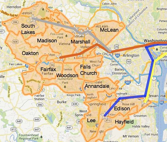
School boundaries near DC METRO stations in Fairfax County, VA
Once Jenny mapped the school boundaries that were potential choices for living near the METRO, she focused on The Ultimate Ranking© to see how the schools compared:
School Rankings for schools serving areas near the METRO
For the high schools serving areas near the METRO, here is how they rank in Fairfax County using our Ultimate Ranking©*
| Ultimate Ranking© |
Fairfax County High Schools |
METRO Line |
|---|---|---|
| 5 | McLean | Orange/Silver |
| 6 | Madison | Orange |
| 7 | Oakton | Orange |
| 9 | Woodson | Orange |
| 12 | Fairfax | Orange |
| 16 | Marshall | Orange/Silver |
| 29 | South Lakes | Silver |
| 32 | Annandale | Blue |
| 34 | Hayfield | Blue/Yellow |
| 35 | Falls Church | Orange |
| 36 | Edison | Blue/Yellow |
| 40 | Lee | Blue |
After her research, Jenny selected the Top 3 school boundaries that met her criteria of:
- Good schools for Max, and
- Have the METRO conveniently close-by
And once Jenny had her short list of school boundaries, she looked for homes for sale in those boundaries.
If you want to commute to DC using the METRO, which boundary would you choose?
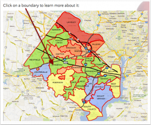
To find out, use the Fairfax County Map of School Boundaries and find the best place to live for your needs:
Log in to the Fairfax County Map of School Boundaries
Log in to the Fairfax County Map of School Boundaries (a.k.a the Affordability Map) to see the location of each of these boundaries within Fairfax County and to choose your ideal boundary.
When you log in to the Fairfax County Map of School Boundaries, you will find:
- Photos and videos
- Highlights of the area covered by each boundary
- Transportation options
- Statistics about housing
- School rankings for schools in each boundary
See you on the other side!
* Click here to log in and access the Ultimate Fairfax County High Schools Ranking©
If you haven’t subscribed yet, why wait?
Downloading The No-Tears Guide to Moving to Fairfax, VA is free, and you’ll get access to our unique home-search (by school boundary).
Plus, you get the Fairfax County Real Estate Affordability Map, AND access to detailed information about each Fairfax County School boundary.
More information about the METRO
For a comprehensive METRO map, METRO train schedules, and METRO bus routes, visit WMATA.com
Stylized METRO map image by RFC1392 on wikipedia, maps by Google





 Everybody is welcome to find a home by school boundary. A school boundary
is simply a geographical area, just like a zip code or a postal city.
 Does anything on this website bug you? Nothing is too small or too big. If there is something we can fix, we'd love to know.

